Dolmen de Champvermeil à Bidon
Chargement de la carte...
Précision de la localisation : 6 - A priori satisfaisante >> Votre avis :
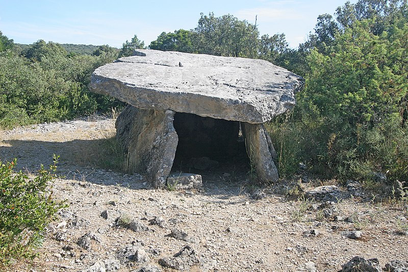
Crédit photo : unknown - Sous licence Creative Commons
Street View Modifier la localisation
 Monument Historique
Adresse renseignée dans la base Mérimée :
07700 Bidon - France
Code Insee de la commune : 07034
Ardèche [07] - Privas - Rhône Alpes (Auvergne-Rhône-Alpes)
Adresse approximative issue des coordonnées GPS (latitude et longitude) :
Eléments protégés :
Dolmen de Champvermeil : classement par arrêté du 21 mars 1910
Périodes de construction :
Néolithique (?)
Propriété privée
Informations pratiques de visite ou services :
Ouvert ou fermé à la visite, location de salle, chambres d'hôtes ?
Autres photographies :

Dolmen de Champvermeil à Bidon
Čeština: Dolmen de Champ-Vermeil This building is indexed in the base Mérimée, a database of architectural heritage maintained by the French Ministry of Culture, under the reference PA00116647. العربية ∙ беларуская (тарашкевіца) ∙ বাংলা ∙ brezhoneg ∙ català ∙ Deutsch ∙ Ελληνικά ∙ English ∙ Esperanto ∙ español ∙ euskara ∙ suomi ∙ français ∙ magyar ∙ italiano ∙ 日本語 ∙ македонски ∙ Nederlands ∙ português ∙ português do Brasil ∙ română ∙ русский ∙ sicilianu ∙ slovenščina ∙ svenska ∙ українська ∙ +/− Camera location44° 21′ 45.37″ N, 4° 33′ 15.92″ E View this and other nearby images on: OpenStreetMap 44.362603; 4.554422

Dolmen de Champvermeil à Bidon
Čeština: Dolmen de Champ-Vermeil This building is indexed in the base Mérimée, a database of architectural heritage maintained by the French Ministry of Culture, under the reference PA00116647. العربية ∙ беларуская (тарашкевіца) ∙ বাংলা ∙ brezhoneg ∙ català ∙ Deutsch ∙ Ελληνικά ∙ English ∙ Esperanto ∙ español ∙ euskara ∙ suomi ∙ français ∙ magyar ∙ italiano ∙ 日本語 ∙ македонски ∙ Nederlands ∙ português ∙ português do Brasil ∙ română ∙ русский ∙ sicilianu ∙ slovenščina ∙ svenska ∙ українська ∙ +/− Camera location44° 21′ 45.37″ N, 4° 33′ 15.92″ E View this and other nearby images on: OpenStreetMap 44.362603; 4.554422

Dolmen de Champvermeil à Bidon
Čeština: Dolmen de Champ-Vermeil This building is indexed in the base Mérimée, a database of architectural heritage maintained by the French Ministry of Culture, under the reference PA00116647. العربية ∙ беларуская (тарашкевіца) ∙ বাংলা ∙ brezhoneg ∙ català ∙ Deutsch ∙ Ελληνικά ∙ English ∙ Esperanto ∙ español ∙ euskara ∙ suomi ∙ français ∙ magyar ∙ italiano ∙ 日本語 ∙ македонски ∙ Nederlands ∙ português ∙ português do Brasil ∙ română ∙ русский ∙ sicilianu ∙ slovenščina ∙ svenska ∙ українська ∙ +/− Camera location44° 21′ 45.37″ N, 4° 33′ 15.92″ E View this and other nearby images on: OpenStreetMap 44.362603; 4.554422

Dolmen de Champvermeil à Bidon
Čeština: Dolmen de Champ-Vermeil This building is indexed in the base Mérimée, a database of architectural heritage maintained by the French Ministry of Culture, under the reference PA00116647. العربية ∙ беларуская (тарашкевіца) ∙ বাংলা ∙ brezhoneg ∙ català ∙ Deutsch ∙ Ελληνικά ∙ English ∙ Esperanto ∙ español ∙ euskara ∙ suomi ∙ français ∙ magyar ∙ italiano ∙ 日本語 ∙ македонски ∙ Nederlands ∙ português ∙ português do Brasil ∙ română ∙ русский ∙ sicilianu ∙ slovenščina ∙ svenska ∙ українська ∙ +/− Camera location44° 21′ 45.37″ N, 4° 33′ 15.92″ E View this and other nearby images on: OpenStreetMap 44.362603; 4.554422

Dolmen de Champvermeil à Bidon
Français : Dolmen de Champvermeil in july 2014

Dolmen de Champvermeil à Bidon
Français : Dolmen de Champvermeil in july 2014


Dolmen de Champvermeil à Bidon
Fiche Mérimée : PA00116647
Dernière mise à jour de la fiche Monumentum : 2026-08-25
Consultez le programme des Journées du Patrimoine pour le Monument Historique Dolmen de Champvermeil situé à Bidon en consultant le programme officiel des JEP 2026.
A proximité :
Bourg-Saint-Andéol - Dolmen
Bourg-Saint-Andéol - Dolmen
Bourg-Saint-Andéol - Dolmen
Bourg-Saint-Andéol - Dolmen
Bourg-Saint-Andéol - Dolmen
Bourg-Saint-Andéol - Dolmen
Bourg-Saint-Andéol - Dolmen
Saint-Martin-d'Ardèche - Grotte Huchard ; grotte n°1 du Ranc-Pointu
Bidon - Grotte de Saint-Marcel
Bidon - Grotte ornée dite grotte de la Tête du Lion
Cartes postales anciennes à proximité :


